The Connections Between Rental Deserts, Segregation, and Restrictive Zoning
Nearly a third of neighborhoods across the US have few options for renter households, limiting where they can live and potentially perpetuating patterns of racial and socioeconomic segregation. In a new working paper, we explore the characteristics and geography of “rental deserts,” which we define as neighborhoods where less than 20 percent of the housing stock is renter-occupied or available to rent. The paper examines the link between neighborhood rental share, segregation by race and income, and restrictive zoning regimes. We found that rental deserts are overwhelmingly white and higher income, and the uneven availability of rental housing is correlated with measures of segregation. Neighborhoods located in municipalities with greater land use restrictions also tend to have a lower share of rental housing, pointing to potential policy levers for opening more areas to renter households.
We first investigated the characteristics of neighborhoods that have a low share of homes occupied by renters or vacant for rent. Rental deserts are disproportionately located in the suburbs, where restrictive land use regulations and not-in-my-backyard (NIMBY) politics can be common, and they are underrepresented in urban neighborhoods. In fact, suburban tracts account for 55 percent of all tracts nationally but 68 percent of rental desert neighborhoods. Rental deserts are dominated by single-family homes, which make up an average of 85 percent of the housing units in these neighborhoods.
Because they offer few options for renters, who are more likely to have lower incomes and to be people of color due to long legacies of discrimination, rental deserts are overwhelmingly white and higher income. While people of color made up two-thirds of the population in high-rental neighborhoods (where at least 80 percent of housing units are renter-occupied or available to rent) on average, just a quarter of the population in rental deserts consisted of people of color. A full 58 percent of rental desert households have higher incomes of at least $75,000, compared to just 32 percent of households in neighborhoods with abundant rental options.
Given that the demographics of neighborhoods vary based on the share of housing that is available for rent, we wanted to further explore the link between the geography of rental housing and racial and income segregation. For this analysis, we calculated divergence index values, which measure the spatial unevenness of rental and owned housing at the neighborhood level relative to the metro level. Rental housing is unevenly distributed in many metros across the country. Three of the five metros with the highest divergence scores—indicating that there is greater variation in the rental share at the neighborhood level relative to the overall metro—are located in Texas, including Dallas, Austin, and Houston. The Northeast is also home to several divergent metros, with New York topping the list and Bridgeport, New Haven, Hartford, and Boston all falling in the top quartile.
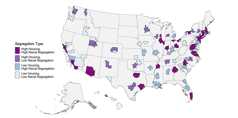
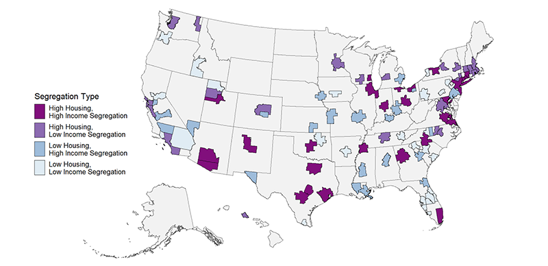
We also calculated divergence index values by race and by income, to identify the relationship between housing segregation and racial or income segregation. Across the largest 100 metros, there is a moderate positive correlation between housing tenure and racial divergence as well as between housing tenure and income divergence. Figure 1 shows metros that have high values for both housing tenure unevenness and racial segregation, while Figure 2 highlights places that have high housing tenure and income segregation. Across these two maps, there are 22 metro areas that score in the top half on all three divergence indices. These metros span the Northeast, South, and Midwest but are relatively absent from the West. Included in the list of metros with high segregation by housing tenure, race, and income are Atlanta, Chicago, and Miami. Three metros—Dallas, Houston, and New York—are in the top quartile of all three measures.
Figure 1. Metro Areas with High Housing and High Racial Segregation
Figure 2. Metro Areas with High Housing and High Income Segregation
Using the National Zoning and Land Use Database (NZLUD) to examine restrictive zoning and land use regulations at the municipal level can help us understand how these policies shape the geography of renting. While zoning itself does not dictate tenure, multifamily homes are predominantly renter-occupied, and restricting construction of these units can limit renters’ options. Neighborhoods with lower shares of rental housing are located in municipalities that impose strict growth controls, require large minimum lot sizes, limit density, and mandate a higher number of parking spots with new construction. Conversely, neighborhoods with a higher share of rental housing are in municipalities with more permissive land use regimes that allow ADUs, provide incentives for inclusionary housing, have by-right multifamily zones, or permit construction at greater heights.
While zoning changes have the potential to increase housing options for renters, creating socioeconomically integrated, mixed-tenure communities will also require building more homes at lower price points, increasing access to homeownership, and expanding housing subsidies. Across different states, a slow but steady wave of reform is paving the way for a relaxing of zoning regulations that allows for the construction of more diverse rental housing typologies. Evidence from other countries also suggests that mandating local zoning reform to reach national affordable housing construction goals can bear fruitful results adding affordable rental units.


